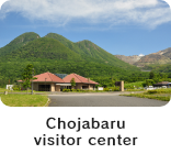
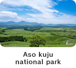
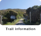


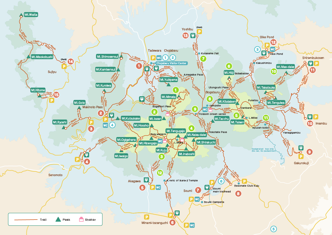
There are many trailheads in the Kuju Range. If you are planning to hike mountains, please refer to the information below. Contact Chojabaru Visitor Center (Tel: 0973-79-2154) for the information about how to get to each trailhead.
-

Mt.Mimata
-

Mt.Iozan
-

Mt.Kuju
-

Mt.Nakadake and Miike pond
-

Mt.Taisen and Oike pond
-

Mt.Hiji
-

Kurasame Fall
-

Bogatsuru
-

Hokkein Onsen
-

A primeval forest in Mt. Kurodake
-

Nyuzan-kobo
-

Ikara-ji Temple
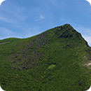
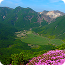
Mt.Mimata
A symbol of Handa Plateau: great for both viewing and hiking
The origin of the name of Mt.Mimata is its image that seems to have three peaks no matter from where it is seen. (another theory exists). In fact, it consists of four peaks. Its massive structure can be seen from Handa Plateau and gives you a strong impression. At the top, you can enjoy walking around two crater remnants called Onabe and Konabe.
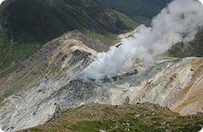
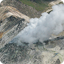
Mt.Iozan
An active volcano still smoking vigorously
Mt. Iozan’s eruption in 1995 is still fresh in our memory. In this mountain, sulfur used to be mined in the Edo period until 1972. The area was very lively then. Still now the gas is coming out from its crater, which tells us clearly that Mt. Iozan is surely active.
At present it is prohibited to hike Mt. Iozan.
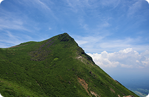
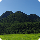
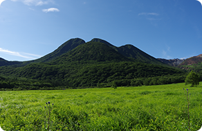
Mt.Kuju
An iconic mountain with a sharp peak in the Kuju Range
Mt. Kuju, whose elevation is 1786.5m, is an iconice mountain of the Kuju range. Hisaya Fukada, who was a novelist and an alpinist, praised this mountain as “the head of the Kuju mountain family” in his well-known book, “100 Famous Japanese Mountains”.
It was thought to be the highest mountain in the Kuju Range before. It is a popular mountain among hikers, and there are various trails leading to this mountain top.
Every year, a ceremony to announce the start of the hiking season is held alternately in Mt. Kuju and Mt. Taisen.
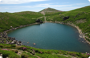
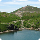
Mt.Nakadake and Miike pond
Mt. Nakadake, whose elevation is 1,791m, is the highest mountain in mainland Kyushu. Just below its peak lies Miike pond. By the pond there was a rear shrine common to Ikara-ji temple and Mt.Kuju Hokkein temple. The water of the pond was specified as holy water. During the severe winter, the pond water freezes and you can walk on the ice.
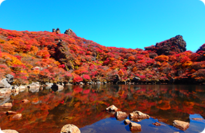
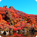
Mt.Taisen and Oike pond
The main peak on the east side of the Kuju Range
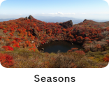
The grand figure of Mt. Taisen fascinates many hikers. It has the main peak on the east side of the Kuju Range. Its elevation is 1786.3m, as high as Mt.Kuju(1786.5m). It has a pond called “Oike” near the peak. This pond is famous for its beauty in the season of autumn leaves. In autumn, colorful leaves paint the mountain and the pond flaming red.
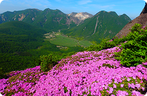
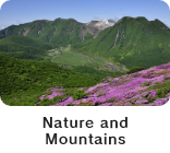
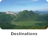
Mt.Hiji
A field of flowers looking down to Bogatsuru
Mt. Hiji rises on the north-eastern side of Bogatsuru. It gets very crowded with hikers during the season of Miyamakirishima (Rhododendron Kiusianum). From its peak you can look down to Bogatsuru and see Mt. Mimata and Mt. Nakadake in front. This wonderful view makes Mt. Hiji more unique and attractive.
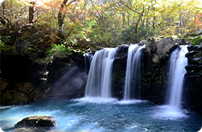
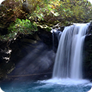
Kurasame Fall
A beautiful water fall where you can enjoy seasonal changes – fresh green, autumn leaves and icicles.
About an hour walk from Yoshibu trailhead takes you to this water fall with a fall of 7m. The water in Bogatsuru goes down through this fall and eventually flows into the Chikugo river. Its surroundings amuse us with fresh green in early summer, colorful leaves in autumn, and crystal icicles in winter. The water fall itself sometimes freezes during severe winter.
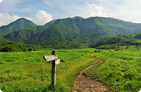
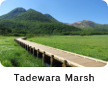
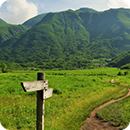
Bogatsuru
A marsh described in the song “Bogatsuru Sanka”.
Bogatsuru, whose elevation is 1,200-1,300m, is a basin surrounded by Kuju mountains. As well as Tadewara Marsh, Bogatsuru is a precious marsh registered under the Ramsar Convention. Every spring, local people burn this field in order to maintain this beautiful grassland. A camp site and restrooms are arranged in this marsh. Imagine how wonderful it is to camp in this grassland, watch glowing mountains against the sunset, and observe the night sky sprinkled with stars!
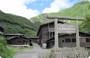
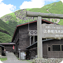
Hokkein Onsen
A highest altitude onsen in Kyushu.
There used to be a temple called “Kujusan-hokkein-hakusui-ji” in southeastern part of Bogatsuru. It was a Tendai Sect temple which was built in 1470. In the Meiji period, a chief of the temple started a hot spring villa in the temple. It has remained as “Hokkein Onsen Sanso” up to today. The hikers heal their tired bodies in its sulfate spring warm water coming directly from a spring source.
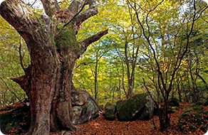
A primeval forest in Mt. Kurodake
A unique primeval forest in Kuju where no tree has been cut down ever
This primeval forest is selected as one of “the 100 selected nature in Japan desired to be left in the 21st century ” and “the 100 Selected Great Forest of water source” The name Kurodake (black mountain) comes from its deep and dark image contrasting with the vast and bright grasslands in Kuju. There are trails through the forest, along which you can stroll around Oike pond, Kakushi-mizu (hidden spring water), and Meisui Fall. This place always amuses us with its seasonal changes of beautiful nature.
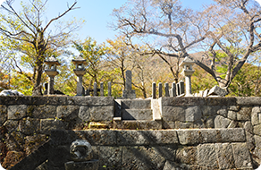
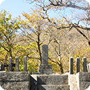
Nyuzan-kobo
A grave of a Load in the Edo period who loved mountains.
This is a grave of the third Load of Bungo-Oka district, Hisakiyo Nakagawa(1615-1681). Hisakiyo loved Mt. Taisen so much that he sometimes had his servant carry him on the saddle attached to the servant’s back and hiked up there. “Nyuzan-ko” was his nickname meaning “a Count who hikes a mountain”. He was loved by the people in his district as a great load. Now he is sleeping in this grave with his two children who died infancy.
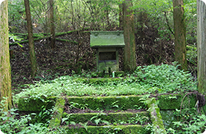
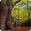
Ikara-ji Temple
A relic which reminds us of an ancient hunting training Yoritomo Minamoto (the founder and the first Shogun of the Kamakura period, lived 1147-1199) would often have
This is a relic of the main temple named “Kuju-san Ikara-ji” in Kuju town, Taketa city. It used to be called “Jison-in”, but Yoritomo Minamoto named this temple “Ikara-ji” in the beginning of the Kamakura period. “Ikara” in Chinese character is 猪鹿狼, each of three character means “a wild boar”, “a deer” and “a wolf”. The name “Ikara-ji” suggests that a hunting training was often held here. Once it was a major base for the practice of Shugendo (Japanese ascetic and shamanistic practice). This historic architecture reminds us of the distant past.

-

Chojabaru(Kuju) Trailhead
Capacity: 356 vehicles,
19 large vehicles


- Nearby facilities
- Chojabaru Visitor Center, shop, accommodation, camp site, bus stop
- Notes
-

Makinoto Pass Trailhead
Capacity: 158 vehicles,
3 large vehicles- Nearby facilities
- shop, bus stop
- Notes
-

Mt.Ryoshidake Trailhead
Capacity: about 10 vehicles
- Nearby facilities
- Notes
-

Senomoto Trailhead
Capacity: about 20 vehicles
- Nearby facilities
- Notes
- Parking space is 300m toward Aso from the trailhead
-

Akagawa Trailhead
Upper side
Capacity:
40 vehiclesLower side
Capacity:
45 vehicles- Nearby facilities
- accomodation
- Notes
- use the restroom in the trailhead on the upper side
-

Minami Trailhead
Upper side
Capacity:
a few vehiclesLower side
Capacity:
200 vehicles- Nearby facilities
- camp site
- Notes
- use the restroom in the trailhead on the lower side
-

Somi Trailhead
Main Trailhead
Capacity:
about
20 vehiclesSomi Camp Site
Capacity:
81 vehicles,
3 large vehicles- Nearby facilities
- camp site
- Notes
- Use the bathroom in Somi camp site
-

Resonate Club Kuju Trailhead
Capacity: about 30 vehicles
- Nearby facilities
- Notes
- Park in the 3rd parking area of Resonate Club
-

Gakurokuji Trailhead
Capacity: about 40 vehicles
- Nearby facilities
- Notes
-

Imamizu Trailhead
Capacity: about 10 vehicles
- Nearby facilities
- Notes
-

Shiramizu Kosen Trailhead
Capacity: a few vehicles
- Nearby facilities
- accommodation
- Notes
-

Oike Trailhead
Capacity: about 181 vehicles,
4 large vehicles- Nearby facilities
- shop
- Notes
-

Yoshibu Trailhead
Private parking Capacity:
100 vehicles(charged)- Nearby facilities
- Notes
-

Mt.Waita, Hizen-yu Trailhead
Private parking Capacity:
about 20 vehicles(charged)- Nearby facilities
- accommodation
- Notes
-

Kuju Forest Park Ski Ground
Capacity: about 40 vehicles
- Nearby facilities
- Notes
- Parking
- Toilet
- Post
* Do not park on the roadside.
* The restrooms are often closed during winter.
* The parking condition may be change in the private parking lot.
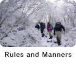
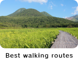
Rules and manners in hiking Kuju mountains
It is indispensable to have the proper knowledge about nature and hiking when you hike mountains.
For the safety of hiking and conservation of precious nature in Kuju, it is everyone’s duty to observe the rules and the manners.
-
1. Plan carefully before hiking
Most of hiking accidents such as getting lost result from a lack of preparation. It is indispensable to check a map or a website and confirm the schedule, time designation, hiking courses, and so on. Know your limit and choose the course to fit your level.
In case of hiking in a group, share the schedule with all members of your party. -
2. Be prepared well
It is dangerous to hike with shoes and clothing which are not suitable for hiking. Enough water, a map, a compass, and rain wears are indispensable for hiking. In winter, you may need a pair of light crampons and the items to walk on snow. Check the conditions and the weather of the mountain beforehand, and pack necessary items to avoid troubles.
contact: Chojabaru Visitor Center Tel: 0973-79-2154 -
3. Post your hiking registration form
Hiking registration form can be a clue to find you when you are involved in an accident or a trouble in the mountain. Before you go into the mountain , it is important to fill in the necessary information and post your hiking registration form. Each trailhead has a post for the form. It is also possible to submit the form on the website:
Oita Prefecture Police Headquarters website about hiking registration form Oita Prefecture Police Headquarters website: Reception page for a hiking registration form -
4. Go to the restroom before starting
The mountaineering toilets are different from the restrooms in town. The toilet in mountains, such as a bio-toilet, cannot deal with much dirt. It also harms nature directly when you defecate and leave trashes such as toilet papaer in the mountain. To protect the nature, it is important to go to the restroom before hiking. (At Kuju-wakare, it is required to donate 100 yen for the use of the composting toilet. It closesd during winter)
-
5. Refrain from hiking with your pets
There is a risk that your pet and wild animals could be infected each other. Your pet also could frighten or bother other hikers on the narrow trails. Please refrain from hiking with your pet.
-
6. Use the rubber tips
Hikers can stick the trail ground with the sharp tips of their trekking poles, and damage the trails.To reduce the impact of the poles on the trail,use the rubber tips on your trekking poles.
-
7. Stay on the trail
Each mountain has the dangerous points or the areas for protecting its vegetation. To prevent hikers from entering these areas, we set the “no entry” signs or extend ropes along these areas. Straying from the route and walking on the plants can damage trails and the ecosystem. Please follow the existing trails.
-
8. Respect wild plants and animals
The Kuju Range is a national park where precious nature and wildlife are well preserved up to the present time. Do not pick wild plants, catch wild creatures or harm them.
-
9. Leave no trace
There is no trash box in the mountain or at the trailhead. It is your responsibility to take your trash back home.
-
10. Be careful in handling a fire
A forest fire could break out due to a hiker’s carelessness, such as throwing cigarette away or pulling the portable gas burner down. To prevent precious nature and wildlife from being destroyed by fire, it is essential to handle fire with the greatest care. It is also forbidden to cook with a fire in the mountain ( using a fire is allowed only at the cooking space in the camp site). In a public parking area, it is forbidden to camp,cook,do laundry, and use a fire.
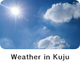
Mountain weather in Kuju
The weather conditions in a mountain change rapidly and can be rainy unexpectedly. The temperature in a mountain is lower and the wind blows stronger windy and cold than in towns. The mountain peak has no trees , so it is very cold and windy.
It is necessary to check the weather in the mountain before hiking. Depending on the weather condition, you need to change or cancel your hiking plan.
When “unsettled weather”, “stormy weather”, “strong wind warning”, or “lightning warning” are predicted, hikers must be pay special attention to the mountain weather conditions.
During the winter season (from December to February), attaching the snow chains to your automobile is required depending on the snow and the road condition. Before leaving home, check the road condition and the traffic information.
Oita Prefecture Road Condition Information Service
http://oita-bosai.force.com/
(You can also check the condition of Makinoto trailhead on a video captured by a live camera.)
